Orienteering for Schools
Club Logo
BDO 2022
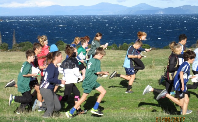
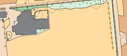
Whakaipo Bay
Club O-Top
Summary: this tab should provide sufficient information to assist teachers to plan, organise and carry out map and orienteering educational activities at their school as well as at some reserves around the Taupo town. This includes education/training material appropriate for primary schools in particular, links to more comprehensive training material particularly on the ONZ (Orienteering NZ) website, maps and sample courses at each local school, equipment available from Taupo Orienteering club and contact email o4schools@taupoorienteering.nz who can assist.
1. Education/training material
a. Sample lesson plan for orienteering taster sessions (45-60 minutes) used in local primary schools
b. Guidelines for simple courses setting for school maps
c. Lesson plan for checking and updating school maps
d. Various templates:
- Kiwsport standards, flags and standard numbers (available on loan from the Club)
- Orienteering map symbols
- Orienteering control descriptions
- Control description templates
- Clipcard template
- O flag paper template for lamination
e. Purple Pen course making software basic description
f. Spa Park permanent short course description using Maprun6 (a phone app)
g. Kiwi O Orienteering for schools. Download [PDF version]
- This has useful exercises and training material
h. The little book of Orienteering techniques (available at cost $12 from Taupo O Club)
- This has the basics as well as more advanced skills
i. ONZ Coaching framework (For participants)
- This has the basics and more advanced skills also
j. For those who want to extend students knowledge of maps and orienteering, an on-line booklet outlining lessons etc is available on the ONZ website schools-resources
2. Maps
a. Each school has an orienteering map in pdf available along with some courses used in 2022 at the educational sessions. This will initially be via a link on the Taupo O web page. For the future they will be available on request via info@taupoorienteering.nz
b. These maps will be checked each year or so and updated where necessary. See the lesson on checking and upgrading school maps in the educational training material section.
c. Other local maps. We do have available some maps in pdf of other park areas that could be made available on request to info@taupoorienteering.nz. This includes Owen Delany Park, 3 Mile Bay, Crown Park and Wharewaka point areas.
- One course uses Maprun6 an app available for download on to Club page on Maprun6 (ie no physical markers at control points)
- The other has physical markers with control numbers that can be used either via another downloadable app or with pen and paper to record course progress. (Not yet available)
3. Equipment
a. A set of control standards with start and finish standards and flags (16 standards with numbers and start and finish standards) is available on loan by emailing info@taupoorienteering.nz
b. Compasses (20) are available on loan by emailing info@taupoorienteering.nz
4. Advice and assistance
a. Advice and assistance for your school maps and orienteering education is available by emailing info@taupoorienteering.nz
b. It is intended that the Club will put together an annual “rogaine big day out” event for all year 5-8 students in the Taupo area at the end of term 2 similar to the events in 2021 and 2022.
c. The Club has in recent years provided short orienteering/rogaine events at the Whakaipo Bay DOC reserve for schools on an on request ad hoc basis. As this involves club members during weekdays etc some expense reimbursement/koha (to be agreed on at the time but in the order of $50-$100) would be necessary.
d. Making courses on orienteering maps. There are a number of ways that this can be done
- By drawing a course on a map with a circle drawing template and ruler and photocopy - simple and easy. (This is how it was done before special course making software became available relatively recently.)
- By using software packages. This is normally done these days for club orienteering events and what was used to make the sample courses for the local schools. At least two software packages are available:
1. Purple Pen (free downloadable) HERE which can use the pdf school maps available as above.
2. Condes 10. This software is used by the club (It has a number of licences).
5. Other school orienteering events
a. There are a number of regular orienteering events held particularly for secondary School students on the ONZ website These include
- North Island Secondary School orienteering champs.
- National Secondary School orienteering champs.
- National Rogaine champs
b. Other websites with secondary school adventure racing information.
- Hillary Challenge and other Hillary courses, click on menu
Teacher guide
What is Orienteering:
• Orienteering is a navigation sport using specially drawn and detailed maps. The control points which have to be visited in numerical order are marked on the map as circles and are always on distinctive features. Each control has a code number for identification and a punch with a unique pin pattern which is used by students to mark a card and prove that they have visited the correct control. (Rogaine is a different format where students can collect controls in any order)
Purpose of Orienteering in schools:
(Aim/Objectives)• Navigation training enables students to make decisions about map interpretation, taking and using compass bearings
• Orienteering is an opportunity for students to experience new spaces within their rohe and become more familiar with the Taupō landscape.
• It demands students to constantly interpret information from the map to the whenua.
• Students are encouraged to classify and analyse land patterns and familiarises them with land use maps.
• It encourages endurance fitness, speed, agility and strength while moving through a variety of terrains.
• All dimensions of Hauora are involved - self-reliance, confidence, decision making, problem solving, perseverance, literacy (symbols), relationships, aspirations and goals, connection to whenua, and physical activity.
What are our map options:
• Hand drawn map: (Lessons found in Kiwi-O-Manual, page 15)
• OCAD Map: (drawn with orienteering map software)
1. Locate your school map on the Taupō Orienteering Website, under the schools tab - school maps.
2. Download your school map and save (PDF). (This general access to all school maps will be just for the period around this session as it is not appropriate that anyone can access these maps which will be periodically updated by Taupo O) A more secure system allowing access by teachers will be developed.
3. Decide whether to make the course manually or using software
a) Manual:
• Print the school map, get out your ruler, circle drawing plastic and coloured pen (red or purple)
• Check the basic guidelines for making simple orienteering courses or do a rogaine (See Simple course setting guidelines for school maps on website)
• There are a number of lessons in the Kiwi-O-manual to support map drawing
b) Software: Purple Pen Programme
• Watch YouTube Purple Pen Tutorial here
• Download Purple Pen software (microsoft software (can be used on Mac OS X or Linux)):
c) Use google earth maps or council maps (MAPI)
• Download council maps
What equipment is involved:
• Physical Equipment: (borrowed from TOC)
• 17 flags (orange and white ‘kites’)
• 17 standards (numbered)
• 20 thumb compasses
• SPORTident and printer
• Downloadable Equipment: (TOC Website)
• Control description/legend
• Control Clip Card
• Control Description Template
• Lesson Plans
Contact: o4schools@taupoorienteering.nz
Orienteering Framework for the Taupō rohe:
Pathway for students/whanau: (see website for further information)
• Students experience orienteering through Kiwisport Taster or a unit of work at school
• Contact Taupō Orienteering Club with the students name and contact email (to receive Taupō orienteering club newsletters with information on events)
• Do local events as an individual, group or with whanau
• Student attends
- Taupō schools district orienteering day,
- Hillary challenge macpac rogaine event (Rotorua),
- Taupō orienteering club events as an individual, group or with whanau,
- Bay of Plenty Orienteering Club events
• Sport Administrator has access to NZ Orienteering Events.
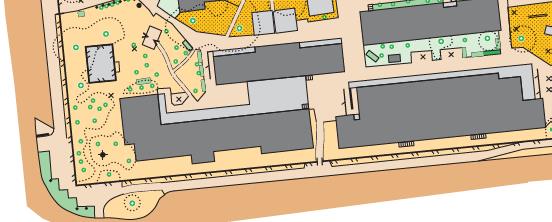
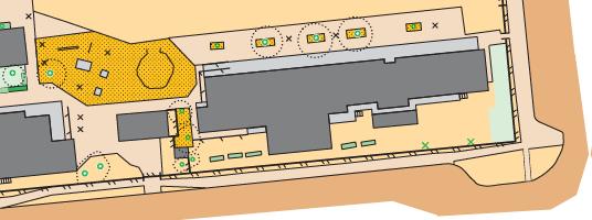
Taupō Community Orienteering Spaces:
• There are many parks within the Taupo District that are mapped for Orienteering. Contact the club first to gain access to the maps and check with the council to make sure no other events are being held.
• Locations that are mapped: Spa Park, Owen Delany Park, Crown Park, Taupō Botanical Gardens (Contact Botanical Gardens Committee), Wharewaka Park, Urban Taupō, Tongariro Domain, Whakaipo Bay.
Taster Lesson plan
Learning Outcomes:
To develop understanding of basic Orienteering principals and exposure to the sport. Create curiosity about the environment around our students and introduce them to a method for exploring that environment.
Year Level: Year 1-8
Equipment Required:
• 15-20 Controls- this includes standards, flags and individual codes per flag (Start and Finish control)
• Spare control flag and standard with punch to model and show students
• Clip Cards- 20 controls on each card
• 2-3 maps per school
• 20x Compasses
• Master Maps
• Plan for all weather – warm hat, gloves, gumboots, raincoat, sunhat etc
Introduction Lesson:
Prep before the day:
• Use the “Master map” (this should have all the controls and their 3 digit code on one map) to put the controls out around the school. It’s a good idea to have three copies of the “master map”, as keen students love to collect controls at the end of the session/lesson.
• Make sure you have the start and finish control.
• Send maps to the school for printing.
• Day before session contact school for confirmation of numbers attending, that maps have been printed.
30 minutes before the session:
• Use “master maps” to place controls around the school
• Place maps into plastic bags and allocate a colour for each map (Red, Blue Yellow)
45-50 minute session:
• Introduce yourself
• Ask if anyone knows what Orienteering is?
• Introduction about what orienteering is: Orienteering is the sport of map reading. It uses its own language of symbols and colours to help you hunt out controls. There are a couple of different ways we use orienteering maps to find controls, but today is about finding the controls on your maps in numerical order. What does the word numerical mean? 1, 2, 3, 4, 5 (most maps will have 5-8 controls in them).
• Now I want you all to pretend you’re a bird flying over your school. Your looking down; what does a tree look like from the sky?, Fence? Building? Pool?
• Students can get into a pair or stay as an individual, no threes allowed
• Get them to align their map or “turn their map” so that it is facing the correct way. This is achieved by using a compass, aligning the North arrow on the compass and the North sign on the map, or by using a major feature in the school (the field, gym or hall are large spaces all kids know).
• Students who had the taster last year also learnt to “thumb”. This is where they use their thumbs to move around the map. When they get to a location on the map that they recognize they move their thumb to that location. This helps you know where you are on the map and hopefully shows you moving closer to the control your look for.
• Students may have also learned about “stepping stones”. Students need to pick three objects on their way to the control that will tell them they are on the right track to the control. If you have time once you have handed out the first map, get students to give you examples of the first three stepping stones they will use to get to that first control. (this is also something you could do with those first few pairs or students back that want an extra challenge).
• Clip cards: Show students how clip cards work (please do explain that at the schools event you will be using SPORTident, which are electronic USB sticks that record which controls you visit). Students do not need to clip the start control, but they always have to clip the finish control. Clip cards give us the ability to check that you have visited the control sights, and visited them in the correct order. At the end of each leg, get students to check off with another student that they have collected all the correct controls.
• Send kids off a few seconds apart. Make them show you that their map is turned correctly before they can go.
• Once students return, if there is time, get them to give feedback on the course, and then give them their next map, and then their third. Students that finish early get to go and help other students or discuss stepping stones.
• Don’t forget to get fast students to help with the tidy up.
Simple course setting guidlines for school maps
(For teachers and students)
Types of courses:
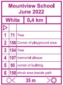
Orienteering courses are graded according to the level of navigational difficulty. Each level has been given a colour name. There are four levels: White, Yellow, Orange and Red. They range from very easy through to very difficult navigation. School maps are somewhat different to Parks, farm and forest maps in that they are generally of smaller area, have lots of buildings, paths and playground equipment.
White Courses:
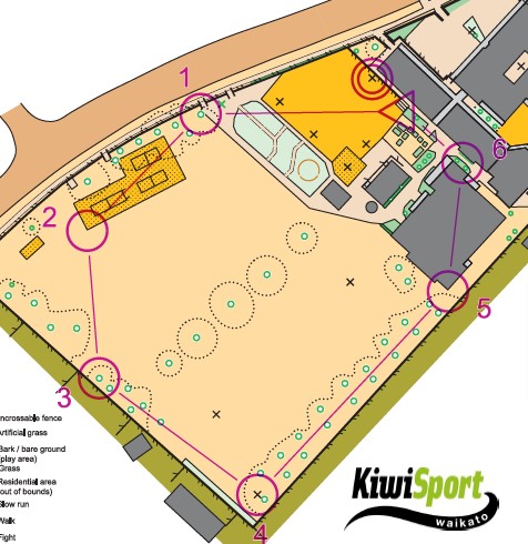
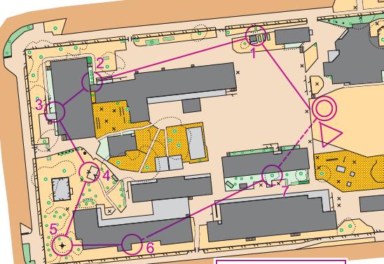
The simplest courses are known as White or “line feature” courses. They normally follow roads, tracks, fences, streams, hedges, tree lines, etc., sometimes referred to as handrails, with controls clearly visible at turning points and on features along the way. For schools this means that some controls are often visible from the prior control ( as long as you are looking in the right direction!). In any case there should not be more than one change of direction to be able to see the next control from a distance. There should be no route choice: ie it should be obvious which is the way to go to the next control. This type of course is what should be used initially. At orienteering club events students aged 10 and under, and older students with little or no orienteering experience do White courses. Below is an example of a white course. Do all the controls comply with the guidelines above?
Yellow Courses:
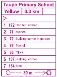
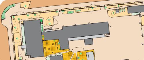
The next level of course is a Yellow course, which also relies exclusively on handrails to navigate between controls, but allows shortcuts and one or at most 2 turning points. This gives the opportunity to follow handrails or to cut across country. There is limited route choice. Control sites should be easily visible from the approach side by any reasonable route. The most able students will soon be taking short-cut routes across the corners of handrail courses confidently and effectively. This will help prepare them for courses on Parks eg Spa Park. There are enough controls to be able to make a longer yellow course, possibly using a small number of controls already on the white or yellow short courses. Below is an example of a short yellow course. Do all the controls follow the guidelines?
Rogaine:
Once you have made a white, yellow and possibly a longer yellow course, you have probably used most if not all of the 16 controls available. You can then just use all the controls you have put out to have a rogaine ie visit all the controls in any order. This involves some prior planning for the students to visit all the controls in an efficient order.
Start and finish points:
Start and finish points are usually relatively close to each other with plenty of room to have the students gather around as well as provide a view of at least part of the courses for the teacher.
[From Kiwi-O adjusted to suit school maps]
Checking and updating school maps
Summary:
Things always change at a school so if the school map is not updated regularly, it soon becomes out of date and to some degree unreliable. The maps can be updated by Taupo Orienteering using their special map making software (OCAD). But of course, someone needs to walk around the school and mark up any changes. This will be done at intervals by a club member, but it can be a very useful exercise to have students check and markup any changes to the map. They will learn the legend and improve their observation and sketching skills. Page 15 in the Kiwi O book also has an exercise on drawing maps.
Suggested procedure:
1. Blow up and cut the school blank map into a number of pieces.
2. Print copies of the school map legend (on website and in handout booklet) and discuss with students.
3. Send them out to identify all the items on their part of the map and markup any removals, deletions, changes.
4. Check that they are legible, scan and send to o4schools@taupoorienteering.nz
Health & Safety and Orienteering
Taupo has a comprehensive H&S Policy which provides guidance on procedures that are used for orienteering events. This mainly applies to events that are held on farms and forests. They are still applicable for urban events and events held in parks.
No doubt schools will use their own H&S guidelines for activities at schools.
Below is an example of the information posted on a notice board at a normal Club Orienteering activity which provides basic information for participants and sets out clearly responsibilities etc in the event of an H&S emergency.
• Hazard ID notice [PDF version]
• Emergency procedures notice [PDF version]
Equipment and templates to assist with running courses
• Kiwsport standards, flags and standard numbers [PDF version]
• Orienteering map symbols [PDF version]
• Orienteering control descriptions [PDF version]
• Control description templates [PDF version]
• Clipcard templates [PDF version]
• O flag paper template [PDF version]
Purple pen
Purple Pen is course setting software for orienteering. Purple Pen makes it easy to design orienteering courses and their associated control descriptions.

Design your courses visually - directly on any OCAD map, OpenOrienteering Map, or PDF map. View the course and the control descriptions at the same time, and simply click on the control descriptions to set the correct description for each control. Purple Pen automatically does all the busywork:
• Print maps with courses overprints directly (without needing OCAD), or export course maps to OCAD or OpenOrienteering Mapper for final printing, or create PDF files for a print shop.
• Use either an OCAD map (OCAD versions 6-12 supported), OpenOrienteering Mapper map, PDF map, or bitmap map (JPG, GIF, PNG, TIFF, BMP).
• Print a perfectly formatted control description sheet, with symbolic or textual descriptions (or both). Textual descriptions are automatically generated. Description sheets can be placed onto the map.
• Calculate the length of each course automatically.
• Make sure that the codes and descriptions of shared controls are in sync.
• View or print an all controls map.
• Easily change control codes — one at a time or all at once.
• Calculate how many competitors are visiting a control or running a leg.
• Print master punch cards for easy control card checking.
• Export course data to event management or electronic punching software (IOF standard XML format, version 2 or version 3).
• View or print several different reports about the courses and controls.
• Download control locations to your mobile GPS device.
• Supports both the IOF 2000 and 2018 control description standards.
Best of all, Purple Pen is completely free software.
Purple Pen runs on Windows XP through Windows 10. On Mac or Linux, a Windows emulator such as Parallels or VirtualBox is required. See here for more information.
Directly Uses OCAD Maps, OpenOrienteering Maps, and PDF maps
Purple Pen directly loads and displays an OCAD map for your event. OCAD versions 6, 7, 8, 9, 10, 11, and 12 are supported. For those using OpenOrienteering Mapper, Purple Pen fully supports that file format (.omap/.xmap) also. You design your courses directly on the OCAD or OOM map, which can be displayed at any level of detail. You can also use a bitmap file such as TIFF or JPEG as a map, or use a PDF file as a map.
Simple User Interface
Purple Pen uses a simple user interface with a single window that displays both the course and control descriptions simultaneously. Many changes can be done by simply clicking on what you want to change and making the change directly. No special "preview" modes -- everything is live all the time. Every change can be undone, with up to 100 levels of undo and redo. Simplicity was the guiding principle in designing Purple Pen.
Conforms to IOF Standards
Purple Pen fully supports the IOF 2004 and 2018 Control Description Standards. Purple Pen can create standard IOF XML interchange files (both version 2 and version 3), which allow the course data to be directly transferred to electronic punching or event management programs.
• Download: here
• Youtube lesson: here
Maprun6

What is MapRunners?
MapRunners has a smart phone app “MapRun6” that competitors load onto their phones.
This software is the brainchild of Peter Effeney, an Orienteer from Brisbane. With a bit of funding from Orienteering Australia but mostly with a huge amount of enthusiasm. This app is now used in many countries around the world.
How does it work?
MapRun6 uses the GPS on your smartphone to track your location. When you get within a few meters of the control site, your phone beeps and vibrates to tell you that the app has registered the control.
If it is a Rogaine, you are automatically allocated the control points and can keep running without a pause.
If it is a linear orienteering event, the app ensures competitors do the controls in the correct order.
You can print out a paper map and keep your phone in your pocket, or use the map on your phone.
Download MapRun6 onto your phone.
Fill in details in the 'Name' section
Go into [Select Event], which will take you to a list of countries and scroll down to New Zealand.
In New Zealand, select Taupo and then the event.
Press [Go To Start], then make your way to the Start. Put Location Services on, if it's not on already. At the start location, your phone will buzz and your time has begun. Do the course!
At the Finish, you instantly see your time and result. If it has been off, put data or wifi on and manually upload your results.
Any questions, email info@taupoorienteering.nz
Safe exercising
Try not to get run over by traffic or bikers if you have your head down looking at your phone and/or map
Unlike our usual events, there isn’t a Controller overseeing road crossings. Some of these courses cross busy roads. We’ve become accustomed to quiet roads and the acceptability of running down the middle to maintain social distancing.
Please shadow kids younger than about high school age if they are doing the courses, especially if they are borrowing your expensive phone.
If you’re using a paper map, stow your phone in a zip pocket so it can’t slip out. Or if you’re using the phone to navigate, use one of those waterproof phone cases that have a cord that goes around your wrist.
General issues noticed with GPS/app
• Need to slow down for controls and make sure phone has good view of the sky – some sites take a while to register (all sites have been checked, so the controls are correct and functioning.)
• Change your phone settings to allow the app to run in the background
• Change the punchTolerance to 10 in [Options and Settings] (for some events this setting may be locked)
• Some background maps on the phone aren't great yet - We're working to adjust our O maps so we can use them as background maps in the future.
• Open the app before you get to the Start. (If you only do it at the Start, you’ll waste seconds – as the course will have already started.)
Test Event
Spa Park, Taupo - short intro course using the phone app MapRun6
• Date/Time: - anytime Spa Park is open
• To register: email your name to info@taupoorienteering.nz and we'll send you a pdf of the map and the unlock code.